Deprecated: Hook wp_smush_should_skip_parse is deprecated since version 3.16.1! Use wp_smush_should_skip_lazy_load instead. in /home/xepoxenu/www/new.stssensors.com/wp-includes/functions.php on line 6078
Hydrology Archives - STS Switzerland (EN)
Deprecated: Hook wp_smush_should_skip_parse is deprecated since version 3.16.1! Use wp_smush_should_skip_lazy_load instead. in /home/xepoxenu/www/new.stssensors.com/wp-includes/functions.php on line 6078
Research project DeichSCHUTZ: Reliable measurements for safer waterfronts

Research project DeichSCHUTZ: Reliable measurements for safer waterfronts

In extreme flood situations, the hopes of those people affected lie solely with the dykes – will they hold or not? A dyke failure like the 2013 flood in Fischbeck (Saxony-Anhalt) caused immense damage to inland areas, which continue to have an impact to this day. The active research project DeichSCHUTZ (dyke protection) at the Bremen University of Applied Sciences is involved in an innovative dyke protection system that could prevent failures of this kind.

In Germany alone, river dykes safeguard many thousands of kilometers of waterfront lands. From today’s technological perspective, dykes consisting of three zones are being constructed. The individual zones, viewed from the water-side to the land-side, are built with steadily increasing porosity, thus affording good drainage of the dyke body during a flood event. In Germany, however, many older dykes of homogenous construction do still exist, such as the dyke breached during a flood of the River Elbe in June 2013 in Fischbeck. In contrast to the 3-zone dykes, older ones are particularly vulnerable to prolonged flood conditions. Water seeps into the dyke itself and its saturation line rises further within the dyke body over extended periods of high water. The further this saturation line rises, the more the ground material is subjected to buoyancy. The dyke thus loses its own essential self-mass, required to counteract against the pressure of high water.

Stabilization of a breach-prone dyke requires enormous resources in material and personnel, as well as time, which in acute flood situations is a scarce commodity.  Backup procedures are thus required, which, in terms of personnel, materials and time commitment, are more effective than layering sandbags on the landward side of the dyke.

Innovative mobile dyke protection system

Christopher Massolle of the Institute for Hydraulic and Coastal Engineering at the Bremen University of Applied Sciences is developing a solution that can considerably reduce the input of time and personnel. With the DeichSCHUTZ research project, sponsored by the Federal Ministry for Education and Research, an innovative, mobile dyke protection system is being tested for stabilizing dykes during flooding events. Measurement technology supplied by STS is also playing a role here.

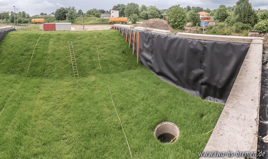
To assess the mobile dyke protection system, a test-dyke has been built on the premises of the Agency for Technical Relief in Hoya. To this end, a U-shaped retention basin holding some 550 cubic meters of water has been constructed, at whose end sits a dyke.

As can be seen in the video, numerous pipes have been deployed at the left side of the dyke. Within these pipes rest ATM/N Level Sensors produced by STS. In the test arrangement, the retention basin is filled with groundwater. Under conditions approaching reality, the water should rise to a level of 3 meters over a period of 30 hours. The submersible level sensor ATM/N  now measure development of the saturation line over this time. With a pressure range from 1 to 250 mH2O and an accuracy of ≤ ± 0.30 %FS (-5 to 50 °C), this is recorded down to the very last centimeter. When the saturation line no longer continues to rise, the mobile dyke protection system is introduced to the water-side slope and should prevent the further penetration of seepage water. The dyke body now continues to drain and the extent of the resulting shift in the saturation line is to be measured by the level sensors employed. It is from these measured results that the functionality of the protection system can lastly be assessed.

Using geomorphometry for hydro-geomorphological analysis in a Mediterranean research catchment

Using geomorphometry for hydro-geomorphological analysis in a Mediterranean research catchment

Abstract

The aim of the paper is to apply an object-based geomorphometric procedure to define the runoff contribution areas and support a hydro-geomorphological analysis on a 3-km2 Mediterranean research catchment (southern Italy).

Daily and subhourly discharge and electrical conductivity data were collected and recorded based on three-year monitoring activity. Hydro10 chemograph analyses on these data revealed a strong seasonal hydrological response in the catchment that were different from the stormflow events that occurred in the wet period and in dry periods. This analysis enabled us to define the hydrochemograph signatures related to increasing flood magnitude, which progressively involves various runoff components (base flow, subsurface flow and surficial flow) and an increasing contributing area to discharge. Field surveys and water table/discharge measurements carried out during a selected storm event enabled us to identify and map specific runoff source 15 areas with homogeneous geomorphological units previously defined as hydro-geomorpho-types (spring points, diffuse seepage along the main channel, seepage along the riparian corridors, diffuse outflow from hillslope taluses and concentrate sapping from colluvial hollows). Following the procedures previously proposed and used by authors for object-based geomorphological mapping, a hydro-geomorphologically-oriented segmentation and classification was performed with an e-Cognition (Trimble, Inc) package. The best agreement with the expert-based geomorphological mapping was obtained with weighted profile and 20 plane curvature sum at different-size windows. Combining the hydro-chemical analysis and object-based hydro-geomorphotype map, the variability of the contribution areas was graphically modelled for the selected event which occurred during the wet season by using the log values of flow accumulation that better fit the contribution areas. The results enabled us to identify the runoff component on hydro-chemograph for each time step and to calculate a specific discharge contribution from each hydro-geomorpho-type. This kind of approach could be useful applied to similar, rainfall-dominated, forested and no-karst 25 catchments in the Mediterranean eco-region.


Source: Domenico Guida1, Albina Cuomo (1), Vincenzo Palmieri (2)
(1) Department of Civil Engineering, University of Salerno, Fisciano, 84084, Italy
(2) ARCADIS, Agency for Soil Defense of the Campania Region, 5 Naples, Italy

Reliable groundwater and surface water monitoring in Romania

Reliable groundwater and surface water monitoring in Romania

A seamless control system with alarm function is required to perform precise water level measurements and to make reliable forecasts on potable water supply, as well as to anticipate floods. Together with its partner MDS Electric Srl, STS has implemented a comprehensive system for groundwater and surface water management in Romania.

Romania draws a major part of its potable water from surface waters such as the Danube, as well as from groundwater resources. A sound management of these natural resources is therefore of huge importance.

To safeguard potable water supply and to protect from flooding, the nation has invested in a comprehensive hydrological measurement infrastructure.

Figure 1: Groundwater measurement point 

In collaboration with its Romanian partner, MDS Electric Srl, over 700 data loggers and more than 350 data transmission systems have thus been installed throughout the country in recent years – also including remote areas. For this reason, the primary investment was in battery-operated measuring instruments, which monitor the current situation on the rivers of the Danube region and also the groundwater resources across the country.

Requirements-specific measurement solutions 

This was a complex undertaking, since each of the submersible probes and data transmission systems deployed required a different assessment and intervention to comply with their respective conditions. An automatic alarm function was also indispensable in this case, should predefined limit values be exceeded.

The permanent monitoring of water levels at important nodes across the potable water supply, as well as the rivers of the Danube region, hinges upon a multitude of requirements:

  • An automated and dependable data transfer via M2M protocol
  • Automatic alarm function when limit value is exceeded
  • Monitoring of water level and temperature, as well as ambient temperature in some instances
  • A server solution with functions for visualizing, evaluating and processing the measured data, as well as the integrated database
  • Easy installation and maintenance
  • On-site support service

For the implementation of this large-scale project, STS opted in pressure and temperature measurements for the DL/N 70 and WMS/GPRS/R/SDI-12 data loggers, or – depending upon requirement – the DTM.OCS.S/N digital data transmitter with Modbus interface to ensure highly precise water level measurement to a 0.03 percent accuracy at critical points.

In association with our local partner MDS Electric Srl, STS was able to realize the entire water level monitoring system from a single source. Each installation point was evaluated on-site by experts from MDS Electric Srl and STS, in order to install a custom solution at each of those individual measurement points. The long-term stability of the pressure measurement technology deployed is also guaranteed. The Modbus transmitter DTM.OCS.S/N excels in this area with an excellent long-term stability of less than 0.1 percent total error per annum. Because of its low energy consumption and robust design, this sensor performs largely maintenance-free for years on end.

Further advantages of the DTM.OCS.S/N in brief:

  • Pressure range: 200mbar…25bar
  • Accuracy: ≤ ± 0.15 / 0.05 / 0.03 % FS
  • Operating temperature: -40… 85 °C
  • Media temperature: -5…80 °C
  • Interface: RS485 with Modbus RTU (standard protocol)
  • Simple implementation in existing Modbus systems
  • Easy adjustment of span and offset
Predicting natural hazards: Level measurement of glacial lakes

Predicting natural hazards: Level measurement of glacial lakes

The glaciers of the Alps are in constant flux. After thawing in the spring and summer, lakes can appear whose levels have to be continuously monitored to detect floods at an early stage. Dependable pressure sensors, level sensors und data loggers are in need here.

The internationally active Swiss company Geopraevent develops, installs and operates high-grade alarm and monitoring systems for various natural hazards, including avalanches, landslides and floods. According to the task and local conditions, the systems are individually designed and implemented. At present, more than 60 alarm and monitoring systems are in use worldwide. When it comes to natural catastrophes, there is no room for error in light of the potentially serious consequences: The technology employed must perform solidly over the years. For this reason, every system is connected to Geopraevent servers to ensure fault-free operation.

Level measurement at the Plaine Morte glacial lakes

This also applies to the system commissioned in 2011 for monitoring the Plaine Morte glacier in the Bernese Alps. As soon as temperatures rise in spring, the glacier begins to melt (see video). From this melting water, three lakes (the Faverges, Vatseret and Strubel) form each year, which then swell constantly over the summer months before finally emptying again.

Danger to the nearby municipality of Lenk, which commissioned the project, arises mainly from the Faverges lake. Like the other two lakes, it exists only in the warmer seasons. After its annual recurrence as a result of snow and glacier melt, the water warms up in the months that follow and then seeks an outflow through the ice. Little by little, this outflow channel becomes further thawed away, meaning that the flow rate constantly increases. In August 2014, for example, some 20 cubic meters of water per second swept down the Trüebach in the direction of Lenk. After emptying of the glacier lake, the cycle will then begin anew the next spring with the onset of the thaw.

To predict a glacial lake breakout and initiate appropriate protective measures, a monitoring system was installed by Geopraevent which ensures an early warning period of one to two days. In the realization of this project, due to outstanding properties of long-term stability and others, STS sensor technology has also been relied upon.

Glacial lake outbreak alarm by SMS

To be able to realistically estimate the danger posed by these glacial lakes at all times, a total of four measuring stations were set up: One each on the three lakes, as well as one on the Trüebach, down which the water flows towards the municipality of Lenk during a glacier lake discharge.

The water level of the three glacial lakes is monitored by means of pressure sensors. To this end, the measuring instruments are submerged into the deepest part of each lake by a helicopter. The level sensors ATM/N/T are connected via a cable to data loggers mounted on a ridge. The data loggers used in this case are solar powered and their collected data is transferred to Geopraevent via mobile telephony. Should the data logger convey dropping levels, this is a clear sign of emptying in the corresponding glacial lake.

Measuring station at the Plaine Morte glacier (Photo: Geopraevent)

Besides lake-level measurement, a level radar also monitors the fill level of the Trüebach. This additional measuring station serves to verify that the glacier lake is also actually emptying out towards the municipality itself. Since the Trüebach passes through a ravine, the level radar is attached to a steel cable stretched across the ravine and is also connected to a datalogger via a cable.

As soon as the pre-defined limit values are undershot or exceeded in the lakes and the Trüebach, those responsible in the community of Lenk are informed automatically by SMS and can then take appropriate measures to prevent flooding.

Better defense against climatic anomalies using dependable level sensors

Better defense against climatic anomalies using dependable level sensors

Over the past few years, Russia has been increasingly struggling with environmental disasters caused by extreme weather conditions. This has not only led to massive material damage, but has also cost human lives. An extensive structural program for better weather forecasting is now destined to diminish those risks and also to support research on climate change.

Weather anomalies, such as the extensive drought of 2010 or the heavy flooding in the Amur region in 2013, generated major attention and concern within Russia, as well as beyond. The Federal Service for Hydrometeorology and Environmental Monitoring (Roshydromet) is responsible for high-precision weather forecasts in Russia and is now to be further bolstered under the terms of the Hydrometeorological Services Modernization Project-II. A little over 139 million dollars has been invested for this purpose.

This large-scale modernization project will be supporting Roshydromet in providing the Russian population, as well as municipal authorities, with reliable and up-to-date information on weather, hydrology and climate. At the same time, Russia is also to be better integrated into the global system of meteorological services.

The individual project measures include:

  • Strengthening of information and communication technologies for providing data on weather, climate and hydrology,
  • Modernization of the observation network,
  • Consolidation of institutions,
  • Optimized access to Roshydromet data and information,
  • The improvement of disaster protection.

With the modernization of Roshydromet’s hydrological observation network in the Lena, Jana, Indigirka, Vilui and Kolyma rivers, special attention has been paid to monitoring technology, which, largely maintenance-free, performs reliably in difficult to access areas and also under harsh conditions such as permafrost.

Fig. 1: Overview of the monitoring sites

Some of the water level sensors essential here were provided by STS and, in collaboration with the Russian partner company Poltraf CIS Co. Ltd., installed at 40 hydrological monitoring stations. The project itself comprised the following requirements:

  • The permanent monitoring of water levels and temperatures, as well as the measurement of rainfall and snowfall. This also includes the installation of surveillance cameras to keep the formation of ice at strategically important points in view.
  • The automatic and error-free transmission of data via GPS or satellite.
  • An alarm function when exceeding defined limits.
  • A server solution for storing the collected data, including a software for the visualization, evaluation and processing of that data.
  • A simple-to-install and easy-to-use technology that will perform for years on end without major maintenance.
  • A professional preparation of the actual monitoring locations.

To meet this demanding assignment, the DTM.OCS.S/N/RS485 Modbus sensor, including others, has been employed. These digital level probes actually measure both level and temperature. The harsh conditions are addressed by its robust design and permissible ambient temperatures of -40 to 80 degrees Celsius, whilst an accuracy of ≤ 0.03% FS ensures precise results at critical measuring points.

Some further advantages of this digital level sensor in brief:

  • High-precision digital level sensor for easy integration into standard Modbus networks
  • Individual adaptation to application through modular design
  • Highest precision over the entire temperature range due to electronic compensation
  • Adjustment of zero offset and measurement range via Modbus
  • Extended long-term stability of measuring cell
  • Sensor can be recalibrated

Subscribe To Our Newsletter

Join our mailing list to receive the latest news and updates from our team.

You have Successfully Subscribed!